Busy Area Feature on Google Maps- A Comprehensive Report
Google Maps has added a new function that allows it to determine how crowded a location is for its users by marking it as a Busy area feature on Google Maps.
Whether people despise crowds or enjoy being surrounded by a sea of folks, Google Maps has the tool for everyone. This feature, dubbed “Busy Area Feature on Google Maps,” will inform users exactly where those amorphous masses of people are so that one can either avoid them or rush to them.
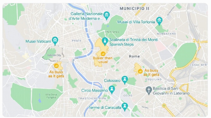
Busy Area, which appears as a pulsing orange circle with a bar graph inside it, is an expansion of the information Maps already gives when people look into public transportation alternatives or tap on specific establishments while in the mobile app.
And, like the other data displays, this feature does more than just inform people how many individuals they will see when they leave the house.
What Is Busy Area Feature On Google Maps?

“Whether people are traveling to their hometown or exploring a new city, anyone can use Busy Area Feature on Google Maps, a new tool that combines real busyness trends to help anyone easily detect when a neighborhood or portion of the town is near or at its busiest,”.
How To Use Busy Area Feature On Google Maps?
- When users zoom in near enough to an area that the map size displays roughly 2,000 feet or 1 kilometer, the bustle icon appears.
- The Busy Region icon will pulse as it comes into focus, and if users zoom in close enough, people will find the area is bounded by a dotted line and tinted orange.
- People Will get information about the area if they tap the symbol, including one with a bar graph showing how busy it is right now and a note about how the current number of people corresponds to the normal day and hour.
- One can also scroll throughout each day of the week to view the normal crowd levels and plan a vacation that meets their desired amount of human interaction in advance.
- This instructional screen also includes instructions for the location in question. Maps remember their last means of transportation, but then people can change it by tapping Directions.
- Lastly, scroll to the bottom to see a “plus code,” which is a string of six or seven numbers and letters, as well as the town or city name, that serves as a general area street address.
- If one doesn’t know the local addresses, anyone could save this code and use it to find that specific location again. Simply type the code into the top-right search box in the Maps app.
Privacy Policy
According to the Google Support website, “To estimate an area’s overall bustle level, they blend real busyness trends from areas like stores, restaurants, parks, cafes, and more.
These trends show how busy an area is on a regular basis, and we mark it as a Busy Area feature on Google Maps when it gets close to or at its busiest.
These algorithms do not calculate activity information for private settings like a house or apartment to preserve their users’ privacy.”
Read Also –
Users should be aware that ‘Area busyness’ never exposes an individual’s exact location. To ensure that all data remains anonymous, safe, and private, Google employs a sophisticated mechanism known as differential privacy.
Furthermore, Google shows the level of activity in a selected “region of interest.” These places never show the exact location of a gathering. It also does not calculate data on the bustle for residential areas such as a house or an apartment.
People May Ask
How Does Google Maps Know Live Busy?
Google uses aggregated and anonymized data from users who have opted into Google Location History to identify popular periods, wait times, and visit duration. If one’s business receives enough visitors from some of these users, popular times, wait times, and visit duration are displayed.
How Accurate Is Google Busy Times?
Humans used 8 weeks of Place meter data (June 26 to August 22) to make the comparison valid because Google indicated their charts use data from the “past couple weeks.” All of the Place meter data utilized in this study has been verified to be accurate to an extent of at least 80%.
How Does Google Maps Determine Travel Time?
Google Maps now uses GPS data from individual phones to estimate traffic movement and speed in real time. This information helps Google calculate journey times by reducing average speeds during periods of heavy traffic and increasing average speeds when conditions are clear.
How Can Google Know Everything?
Through Google search: Whatever and whenever people have searched on Google, the internet giant knows through its search engine. Anyone can disable this by visiting Google’s My Activity page and selecting the “Web & App Activity” tab.
Does Google Maps Give Verbal?
By enabling voice navigation, one may have Google Maps speak to them and provide users verbal directions and prompts to help them find their location. To guarantee that people really can hear the voice feature’s directions, users may need to enable or increase the volume.
What Is Google Map Features?
Set route preferences: When using Google Maps to get to a location, one can choose their preferred path. Learn how to avoid paying tolls, taking ferries, and driving on freeways.
Explore the area with Street View: Users may browse photos of places in Maps and visually explore the area. Discover how to utilize Google Street View.


